
| Hungry Hatch [a.k.a. Netts Farm] Rushton Road Fletching |
| Historical records | |||||
| 27th Sep 1583 | Copyholder | Thomas Tye | Hungers Hatch | Buckhurst Terrier | |
Thomas Tye holds tenement called Hungers Hatch, with a little piece of waste ground thereunto belonging, bounds:
| |||||
| c 1825 |  | Part of the 1 inch to 1 mile map of Sussex produced in 1825 by Christopher and John Greenwood | Netts Farm | ||
| 30th Mar 1851 | Census | Head, out of business, occupation: farmer | Charles Cave, farmer | Hunger Hutch, Rushton Road | 1851 Census Fletching, Sussex |
| Wife | Charlotte Cave | ||||
| Servant; occupation: general servant | Frances Divall | ||||
| 1861 | Jesse Bellingham, M, Head, married, age 63, born Rotherfield, Sussex; employs 3 men and 2 boys; occupation: farmer | Jesse Bellingham, farmer | Hungry Hatch | 1861 Census | |
| 1861 | Philidelphia Bellingham, F, Wife, married, age 62, born Rotherfield, Sussex | Philadelphia Bellingham [Turner] | Hungry Hatch | 1861 Census | |
| 1861 | Jesse Bellingham, M, Son, single, age 28, born Fletching, Sussex | Jesse Bellingham, registrar of Births and Deaths, and relieving officer | Hungry Hatch | 1861 Census | |
| 1861 | Edward Bellingham, M, Grandson, single, age 5, born Rotherfield, Sussex | Edward Bellingham | Hungry Hatch | 1861 Census | |
| c 1875 | 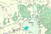 | Part of the 6 inch to 1 mile map of Sussex produced in 1875 by Ordnance Survey | Hungry Hatch | ||
The Weald is at Database version 14.05 which has ongoing updates to the 395,000 people; 9,000 places; 613 maps; 3,308 pictures, engravings and photographs; and 248 books loaded in the previous version


