| Historical records |
|
| c 1724 | 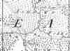 | Part of the 1 inch to 1 mile map of Sussex produced in 1724 by Richard Budgen | | Charlwood | |
|
| c 1795 | 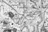 | Part of the 1 inch to 1 mile map of Sussex produced in 1795 by William Gardner and Thomas Gream | | Chellwood | |
|
| c 1825 | 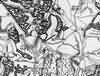 | Part of the 1 inch to 1 mile map of Sussex produced in 1825 by Christopher and John Greenwood | | Chelwood | |
|
| 1867 | Directory entry | Wheeler John, farmer, Chelwood Common farm | | Chelwood Common farm | Post Office Directory |
|
| 1874 | Directory entry | Wheeler John, farmer, Chelwood Common farm | | Chelwood Common farm | Post Office Directory |
|
| c 1875 | 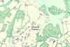 | Part of the 6 inch to 1 mile map of Sussex produced in 1875 by Ordnance Survey | | Chelwood Farm | |
|
| 1882 | Directory entry | Wheeler John, farmer, Chelwood common farm | | Chelwood common farm | Kelly's Directory |
|
| 1888 | Directory entry | Baker, Spencer, Chelwood farm | | Chelwood farm | Brooker's Guide |


