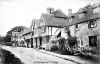
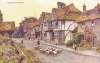
| Chiddingstone |
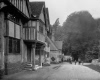
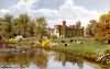
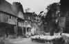
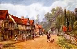 Chiddingstone Village in 1900 |
| The Parish of Chidingstone lies below the sand hills, and consequently in the district called the Weald. It is about six miles in length from north to south; but not more than two on an average in breadth; the river Eden crosses the centre of it towards Penshurst, where it joins the river Medway. Northward of this stream the country is very much covered with woods, among them are situated Sharp's-place,.Boar place, and nearer the foot of the hill, Boar's-hill, usually called Bowsell-gate, which names, among many others of the like import hereabouts, certainly took their origin from the wild boars, formerly in plenty in these parts. About a mile southward from the Eden is the village of Chidingstone, which from the rise on which it is situated was called High-street, in which is the seat of the elder branch of the family of Streatfield, called Highsreet house, having been their residence from the time of king James I. as it is now of Henry Streatfield, esq. The face of the country throughout this parish is much the same as those last described, within the Weald the soil is very moist, and in general a deep strong clay, the grounds having many fine large oaks interspersed over them, and in the broad hedge rows round the fields. There are many greens and small hamlets in different parts of it, as Wickhurst-green, Bow-beach, Hill-heath, Carey's-cross, Ranesley-heath, and, others. At the southern bounds of this parish the branch of the river Medway, which rises at Gravely hill, in Sussex, directs its course eastward, and divides the two counties. extract from Hasted's History of Kent published in 1797 |
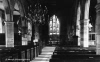
| Parish & other records | Before 1500 |
1500 to 1550 |
1550 to 1600 |
1600 to 1650 |
1650 to 1700 |
1700 to 1725 |
1725 to 1750 |
1750 to 1775 |
1775 to 1800 |
1800 to 1825 |
1825 to 1850 |
1850 to 1875 |
1875 to 1900 |
1900 to 1925 |
1925 to 1950 |
1950 to 1975 |
1975 to 2000 |
After 2000 |
||
| 2253 | Births | 7 | 16 | 11 | 13 | 3 | 41 | 102 | 357 | 662 | 737 | 300 | 3 | 1 | ||||||
| 609 | Christenings | 5 | 12 | 6 | 10 | 6 | 31 | 63 | 130 | 260 | 86 | |||||||||
| 73 | Marriages | 1 | 1 | 1 | 1 | 1 | 4 | 11 | 28 | 19 | 2 | 3 | 1 | |||||||
| 96 | Deaths | 2 | 3 | 5 | 7 | 4 | 9 | 8 | 15 | 21 | 11 | 8 | 3 | |||||||
| 123 | Burials | 2 | 3 | 5 | 25 | 15 | 11 | 12 | 13 | 20 | 10 | 3 | 4 | |||||||
| Books and other documents | |
| Published | Title, author and references |
| 1766 | The History of Tunbridge Wells by Thomas Benge Burr ⇒ p. 187 |
| 1797 | The History and Topographical Survey of the County of Kent - Volume III by Edward Hasted ⇒ p. 210 |
| 1814 | An Historical, Topographical and Descriptive Account of the Weald of Kent by T. D. W. Dearn ⇒ p. 66 |
| 1832 | Descriptive Sketches of Tunbridge Wells and the Calverley Estate by John Britton, F.S.A. ⇒ p. 140 |
| 1839 | Directory of Kent, Surrey & Sussex ⇒ entry |
| 1840 | New Guide for Tunbridge Wells by John Colbran and edited by James Phippen ⇒ p. 258 |
| 1874 | A History of The Weald of Kent with an outline of the History of the County to the present time, Volume II by Robert Furley, F.S.A. ⇒ p. 4; p. 12; p. 707 |
| 1882 | Kelly's Directory of Kent by E. R. Kelly, M.A., F.S.S. ⇒ entry |
| 1909 | English Homes and Villages (Kent & Sussex) also published as Tunbridge Wells and its Neighbourhood by Lady Hope ⇒ p. 152 |
| 1914 | Highways and Byways in Kent by Walter Jerrold with Illustrations by Hugh Thomson ⇒ p. 336 |
| 2010 | Extracts from the Maidstone Journal (1786-1851) relating to Edenbridge, Hever, Chiddingstone, Westerham, Brasted and Hever by Lionel Cole ⇒ Journal |
| 2012 | An Index to the People of Chiddingstone between 1820 and 1851 by Lionel Cole ⇒ Book |
| 2013 | Judicial Documents concerning Chiddingstone, Hever, Edenbridge, Westerham, Brasted and Sundridge by Lionel Cole ⇒ page |
| 2023 | An Index to the Places of Chiddingstone between 1200 and 1851 by Lionel Cole ⇒ Book |
| 2024 | An Index to the People of Chiddingstone between 1785 and 1820 by Lionel Cole ⇒ Book |
| 2025 | An Index to the People of Chiddingstone between 1735 and 1785 by Lionel Cole ⇒ Book |
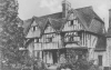
| Places and properties in Chiddingstone - a directory of homes, farms, churches, schools, inns, and other places of interest that existed prior to 1900 has been compiled from Post Office directories, Kelly's directories, Trade directories, Census data, Ordnance survey maps and books of the period |
The Weald is at Database version 14.05 which has ongoing updates to the 395,000 people; 9,000 places; 613 maps; 3,308 pictures, engravings and photographs; and 248 books loaded in the previous version