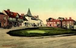
The Weald of Kent, Surrey and Sussex
Westerham
The Green in 1905
The Green in 1905
Visit Westerham Website
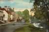
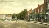
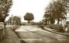
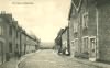
Westerham is a parish of large extent, and … is much longer than it is in breadth. It extends to the summit of the range of chalk hills northward, where it bounds to Cowden, and southward, beyond the sand hill, into the Weald. In the whole it is about five miles and a half from north to south, and on an average, in breadth, about two miles and a half, bounding westward to Surry. … The high road from Maidstone and Sevenoke, across this parish, midway between these hills, towards Surry; on it is situated the town of Westerham, a very healthy and pleasant situation, at the west end of which is a seat, which has for many years belonged to the family of Price, and continues so now; and at the east end is the, church and parsonage; besides which there are many genteel houses dispersed in it. The high road from Bromley by Leaves-green joins the Sevenoke road, on the north side of the town, near the south side of which is the mansion of Squeries. The river Darent takes its rise in this parish, at a small distance southward from Squeries, and having supplied the grounds of it, runs along near the south side of the town, and having turned a mill, it takes its course north east, and in about half a mile, passes by Hill-park towards Brasted; northward from hence the land rises about a mile and a half to the foot of the chalk hills, near which, close to the boundaries of Surry, is Gasum. From the town southward, to the summit of the sand hill, is about two miles, over a very hilly unfertile soil, interspersed with commons, waste rough grounds, and woods, among which, bounding to Surry, is Kent-hatch, taking its name from its situation; and on the summit of the hill the hamlet of Well-street, and a seat called Mariners, belonging to Mr. Stafford Whitaker; from whence, down the hill, this parish extends two miles further southward into the Weald, where, near the boundaries of it, is the estate of Broxham; the soil over which is a stiff clay and deep tillage land.
extract from Hasted's History of Kent published in 1797

Parish & other records Before
1500
1500
to
1550
1550
to
1600
1600
to
1650
1650
to
1700
1700
to
1725
1725
to
1750
1750
to
1775
1775
to
1800
1800
to
1825
1825
to
1850
1850
to
1875
1875
to
1900
1900
to
1925
1925
to
1950
1950
to
1975
1975
to
2000
After
2000

2725Births171915177252495339249226
356Christenings71714188862121101
63Marriages1263882101841
46Deaths106992211411
39Burials106992111
 
Books and other documents
Published Title, author and references
1797The History and Topographical Survey of the County of Kent - Volume III by Edward Hastedp. 158
1839Directory of Kent, Surrey & Sussex ⇒ entry
1840New Guide for Tunbridge Wells by John Colbran and edited by James Phippen ⇒ p. 375
1871A History of The Weald of Kent with an outline of the Early History of the County, Volume I. by Robert Furley, F.S.A.Domesday p. 226; p. 240; p. 400
1874A History of The Weald of Kent with an outline of the History of the County to the present time, Volume II by Robert Furley, F.S.A.p. 44; p. 126; p. 127; p. 189; p. 210; p. 241; p. 243; p. 247; p. 403; General Wolfe p. 632; p. 726; p. 755; p. 842
1882Kelly's Directory of Kent by E. R. Kelly, M.A., F.S.S. ⇒ entry
1886Squerryes Court, The Camp, and The Pictures by Canon Scott Robertson ⇒ p. 134
1903Hookers Household Almanack and Directory ⇒ entry
1909English Homes and Villages (Kent & Sussex)
also published as
Tunbridge Wells and its Neighbourhood by Lady Hope ⇒ p. 156
1912Edenbridge by Henry L. Somers-Cocks, M.A. & V.F. Boyson ⇒ p. 190
1914Highways and Byways in Kent by Walter Jerrold with Illustrations by Hugh Thomson ⇒ p. 341
2010Extracts from the Maidstone Journal (1786-1851) relating to Edenbridge, Hever, Chiddingstone, Westerham, Brasted and Hever by Lionel ColeJournal
2014Westerham Parish Registers by Lionel Colepage
2014Westerham Manorial Rolls - 1428 to 1787 by Lionel Colep. 0
2014Westerham Wills - 1444 to 1849 by Lionel Colep. 1

People of note
Wolfe, Lieut. Gen. James
(1727 - 1759)
Soldier and "Liberator of Québec"
       

Picturesmore pictures 

The Green - 1830

Quebec House - 1830

Force Green Farm - c 1850

Kent Hatch - 4th Nov 1882

Standard 3rd, National Girls Westerham School - 1889

The Kings Arms - 1890

The Long Pond - c 1900
 

Westerham, looking East - c 1900

Delegardes Farm - c 1900

Westerham View - c 1900

Dunsdale Gardens - c 1900

Westbury Terrace - c 1900

Railway Station - c 1900

New Street - c 1900
 

Places and properties in Westerham - a directory of homes, farms, churches, schools, inns, and other places of interest that existed prior to 1900 has been compiled from Post Office directories, Kelly's directories, Trade directories, Census data, Ordnance survey maps and books of the period
Churches, Inns,
Schools, Shops
and other places of interest
Almshouse, New Street
Almshouses, High Street
Crockham Hill School, Crockham Hill
Crown Beerhouse, High Street
Eagle Boot Stores, High Street
Fountain Tavern Coffee Shop, High Street
George & Dragon Hotel, High Street
Grasshopper Inn, High Street
High Street Inn, High Street
Holy Trinity Church, Crockham Hill
Kings Arms Hotel, High Street
Moreton Almshouses, London Road
National School for Boys
National School for Girls and Infants
Post Office, Crockham Hill
Public Hall, High Street
Quebec House
Rifleman Beerhouse, High Street
St. Mary's Church, High Street
St. Mary's School, Hosey Hill
Swan Beerhouse, London Road
The Crown, London Road
The Parsonage, Crockham Hill
The Royal Oak, Crockham Hill
Valence [a.k.a. Valons, Hill Park]
Vicarage House, High Street
Warde Arms Inn, High Street
Wheatlands Hill, Crockham Hill
Wolfe House School, London Road
Wolfe Inn, High Street
 
Roads and Streets
Board's Hill
Clifton Place
Common Lane
Crockham Hill
Croydon Road
Edenbridge Road
Farley Common
Farley Common, Farley Common
Force Green
French Street
Froghole
High Street
Horns Hill
Hosey Hill
Hosey Road
Kent Hatch
Limpsfield Road
Lodge Lane
London Road
Mill Lane
New Street
Pilgrims Road
Pootings
Squerryes Park
Stone Street
Stratton Terrace
The Green
 
Homes and Farms
A-L
Alma Cottages, New Street
Bank Cottages, High Street
Belle Vue, New Street
Belle Vue Terrace, New Street
Betsoms Farm, Pilgrims Road
Blacksmiths Forge, High Street
Brewery Cottages, High Street
Broxham Villa, Pootings
Buttles, Froghole
Canterbury Cottage, High Street
Chapel House, High Street
Charmans Farm
Charts Edge Mansion, Hosey Hill
Chartwell
Church Alley
Close Farm, Froghole
Club House, Crockham Hill
Cokeham Farm, Pootings
Commerce House, High Street
Copthall Cottages, High Street
Corn Store, London Road
Court Lodge Farm, London Road
Covers, Limpsfield Road
Covers Springfields, Limpsfield Road
Crockham Farm, Crockham Hill
Crockham Grange, Crockham Hill
Crockham Hill Dairy Farm, Edenbridge Road
Crockham Hill Farm, Crockham Hill
Crockham House, Crockham Hill
Current Hill Cottages, London Road
Dale Cottages, Mill Lane
Darenth
Delegards, Croydon Road
Dennetts Lodge, Crockham Hill
Duncans Yard
Dunsdale
Early Lands, Edenbridge Road
Elm View, High Street
Fairlight, London Road
Force Green Farm, Force Green
Garden Cottage, Lodge Lane
Gatlands, High Street
Gaysham Farm, Croydon Road
Gilhams, French Street
Gordon Villa, High Street
Gospel Hall Cottage, High Street
Grange Cottage, Lodge Lane
Gratitude Place, High Street
Grosvenor House
Herbert Lodge, Hosey Hill
Homes, High Street
Hope Cottage, High Street
Hurst Farm, Crockham Hill
Inglefields Cottages, High Street
Ivy House, Force Green
Kirk Gate, High Street
Larkfield, Froghole
Lewins, Crockham Hill
Lime Works, Pilgrims Road
Little Betsoms Hill, Pilgrims Road
London House, High Street
 
Homes and Farms
M-Z
Magdala House, High Street
Manor House, High Street
Mapleton, Pootings
Mariners, Froghole
Medhurst, Pootings
Merle Cottage, High Street
Milk Cottages, High Street
Mill House, High Street
Mill Lane Cottages, Mill Lane
Mills Water
Moreton Cottage, High Street
Newlands, Crockham Hill
Nursery Cottage, New Street
Oak Lodge, London Road
Oaklands, Pootings
Old Ivy House
Orchard Villas, High Street
Palace Road Cottages, Pilgrims Road
Palins Cottages
Park Gate Cottages, Squerryes Park
Park Hill [a.k.a. Hill Park], Pilgrims Road
Park View, High Street
Patients Farm, London Road
Pear Tree Villa, High Street
Pilgrim House, Pilgrims Road
Pollards
Puddledock
Pywell Cottages, High Street
Quebec Cottages, High Street
Railway Cottages, London Road
Railway Station, London Road
Redlands, Edenbridge Road
Reds House, Pilgrims Road
Rooks Nest Cottage, Squerryes Park
Rose Cottage, Lodge Lane
Rose Villa, High Street
Roseville, High Street
Rushetts Cottages, Edenbridge Road
Rusholme, Crockham Hill
Shops, High Street
Slakes, Hosey Hill
South Bank, London Road
Southview, London Road
Spittals Cottage, Kent Hatch
Spring Gardens, High Street
Springfield Cottages, High Street
Squerryes Court, Squerryes Park
Squerryes Farm, Squerryes Park
Squerryes Farm Cottages, Squerryes Park
Squerryes Gardens, Squerryes Park
Squerryes Lodge, Squerryes Park
Squerryes Stables, Squerryes Park
Stratton House, Stratton Terrace
Sunny Bank, London Road
Sygnet [a.k.a. Cygnet] Cottage, Hosey Hill
The Beeches, High Street
The Grange, High Street
The Laurels, High Street
The Pheasantry, High Street
Uplands Farm, Froghole
Vicarage Cottage, High Street
Wardes Cottage, High Street
Warren Farm, Crockham Hill
Westerham Hill Cottage, Pilgrims Road
Westerham Post Office, High Street
White Post, Crockham Hill
White Post, Pootings
William Finnis Watkins Brewery House
Willy at Heath, Crockham Hill
Winterton House, High Street
Woodville Cottage, High Street
Workhouse Yard
Yew Tree Cottage, High Street

The Weald is at  Database version 14.05 which has ongoing updates to the 395,000 people; 9,000 places; 613 maps; 3,308 pictures, engravings and photographs; and 248 books loaded in the previous version

ODNB  
British Libarary  
High Weald  
Sussex Record Society  
Sussex Archaeological Society  
Kent Archaeological Society  
Mid Kent Marriages  
Ancestry  
Genes Reunited  
International Genealogical Index  
National Archives  

Top
of the
page