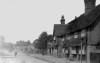
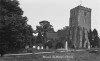
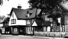
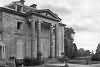
| Brasted |
| The village of Brasted is situated on the high road to Westerham, which leads through the parish westward, midway between the two ranges of the chalk and the sand hills, to the former of which this parish extends, about a mile in length. About a quarter of a mile southward of the village, the river Darent flows through the parish eastward, a little southward of which is the church, and near the foot of the chalk hill, Brasted-court lodge, within the hundred of Westerham and Eatonbridge. Near the east end of the village is Brasted place, southward from which is a large parcel of waste, rough, and woody ground, called Brasted Chart common, extending for two miles to the sand hill, below which it extends for some length into the Weald, where it has the name of Brasted Weald, in like manner as the other parishes mentioned before; where, at the southern boundary of it, is the estate, called Delaware. The whole parish, notwithstanding its great length, at no part of it exceeds a mile in width; the soil of it, above the hill, excepting near the river, is but very indifferent, being near the northern hills chalky, and near the southern hills an unfertile sand; below the latter it is a stiff clay. extract from Hasted's History of Kent published in 1797 |
| Parish & other records | Before 1500 |
1500 to 1550 |
1550 to 1600 |
1600 to 1650 |
1650 to 1700 |
1700 to 1725 |
1725 to 1750 |
1750 to 1775 |
1775 to 1800 |
1800 to 1825 |
1825 to 1850 |
1850 to 1875 |
1875 to 1900 |
1900 to 1925 |
1925 to 1950 |
1950 to 1975 |
1975 to 2000 |
After 2000 |
||
| 1174 | Births | 1 | 3 | 17 | 166 | 302 | 439 | 245 | 1 | |||||||||||
| 194 | Christenings | 3 | 8 | 73 | 88 | 21 | 1 | |||||||||||||
| 30 | Marriages | 1 | 1 | 9 | 12 | 4 | 2 | 1 | ||||||||||||
| 143 | Deaths | 3 | 14 | 23 | 41 | 48 | 12 | 1 | 1 | |||||||||||
| 141 | Burials | 3 | 14 | 22 | 44 | 46 | 12 | |||||||||||||
| Books and other documents | |
| Published | Title, author and references |
| 1797 | The History and Topographical Survey of the County of Kent - Volume III by Edward Hasted ⇒ p. 146 |
| 1839 | Directory of Kent, Surrey & Sussex ⇒ entry |
| 1871 | A History of The Weald of Kent with an outline of the Early History of the County, Volume I. by Robert Furley, F.S.A. ⇒ vill of p. 120; in Domesday p. 225; in Domesday p. 240; peculiar of Canterbury p. 400 |
| 1874 | A History of The Weald of Kent with an outline of the History of the County to the present time, Volume II by Robert Furley, F.S.A. ⇒ p. 44; p. 45; p. 127; p. 163; p. 166; p. 222; p. 705; p. 743; p. 801; p. 838 |
| 1882 | Kelly's Directory of Kent by E. R. Kelly, M.A., F.S.S. ⇒ entry |
| 1903 | Hookers Household Almanack and Directory ⇒ entry |
| 1912 | Edenbridge by Henry L. Somers-Cocks, M.A. & V.F. Boyson ⇒ p. 82 |
| 1933 | Country Houses of Kent by Arthur Oswald ⇒ p. 65 |
| 2010 | Extracts from the Maidstone Journal (1786-1851) relating to Edenbridge, Hever, Chiddingstone, Westerham, Brasted and Hever by Lionel Cole ⇒ Journal |
| 2014 | The Diary of Alfred Chilman (1826-1902) by Alfred Chilman ⇒ Diary |
| Places and properties in Brasted - a directory of homes, farms, churches, schools, inns, and other places of interest that existed prior to 1900 has been compiled from Post Office directories, Kelly's directories, Trade directories, Census data, Ordnance survey maps and books of the period |
The Weald is at Database version 14.05 which has ongoing updates to the 395,000 people; 9,000 places; 613 maps; 3,308 pictures, engravings and photographs; and 248 books loaded in the previous version