| Buxted |
| ||||||||||||||||||||||
| "Buxted is truly beautiful both inside and out - that is to say, it has lovely scenery of its own and there are numerous viewpoints from which the beautiful country around, far and near, may be seen. What have we? A magnificent park containing the finest avenue of Scotch firs in England, another avenue of various trees and a superb grove, of ancient limes; many pretty walks by woodland and stream; deep-cut lanes with picturesque sand-rock banks; rippling brooks rushing beneath green arches of hazel and willow; open commons clad with bracken and gorse; valley and hill, holt and copse, hedgerow and footpath, arable land and meadow - every variety of rural scenery, and almost every kind of tree and shrub to set it off. Even man's contribution to the picture is full of charm, for many of the buildings in the parish add to the natural beauty of it - they are not like many modern erections, dreadful blots on the landscape. The parish church is a fine example of mediaeval architecture; the 16th century Hogge House fitly crowns the little cliff on which it stands; the half-timbered houses of Bevingford and Maypole Cottages, Stonehouse Farm, the old moated Rectory house, Hendall Farmhouse with its portico, the iron-gate and approach to New House, the Eight Bells Inn with its timbered front, Five Chimneys with its clustered smoke-stack, The Toll with fine timber-work, and several quaint oast-houses - all add their own peculiar charm. Besides all these there are the unique cave-dwellings at the Hermitage, of partly natural and partly human origin, that form a picturesque feature in the landscape quite unique." extract from Buxted the Beautiful written in 1929 by Rev. K.H. MacDermott | ||||||||||||||||||||||
Buxted is a village and parish in the East Grinstead division of Sussex, in the hundred of Loxfield Dorset, rape of Pevensey, rural deanery of Uckfield, archdeaconry of Lewes and diocese of Chichester. Buxted includes Hadlow Down (until 1st October 1905 when it was formed into its own civil parish); Pound Green; Five Ash Down and High Hurstwood (which was formed as a separate ecclesiastical parish on 22nd December 1871). It is 42 miles south of London
Buxted is referred to in historical documents as Buxsted; Bocstead; and Buxstead and has its origins in the Anglo-Saxon words 'boc' meaning beech and 'stede' meaning a place. Buxted originally is probably 'the place of beech trees' | ||||||||||||||||||||||
| Buxted historical notes has been derived from the same sources to highlight Buxted's key events in chronological order | ||||||||||||||||||||||
| Parish & other records | Before 1500 |
1500 to 1550 |
1550 to 1600 |
1600 to 1650 |
1650 to 1700 |
1700 to 1725 |
1725 to 1750 |
1750 to 1775 |
1775 to 1800 |
1800 to 1825 |
1825 to 1850 |
1850 to 1875 |
1875 to 1900 |
1900 to 1925 |
1925 to 1950 |
1950 to 1975 |
1975 to 2000 |
After 2000 |
||
| 6985 | Births | 1 | 157 | 339 | 300 | 157 | 217 | 308 | 547 | 945 | 1452 | 1466 | 1042 | 52 | 2 | |||||
| 3895 | Christenings | 159 | 339 | 303 | 162 | 206 | 294 | 385 | 551 | 647 | 596 | 244 | 8 | 1 | ||||||
| 833 | Marriages | 45 | 103 | 50 | 19 | 29 | 62 | 71 | 135 | 141 | 147 | 27 | 3 | 1 | ||||||
| 323 | Deaths | 5 | 17 | 29 | 14 | 17 | 13 | 8 | 39 | 63 | 71 | 41 | 2 | 2 | 2 | |||||
| 321 | Burials | 4 | 17 | 29 | 14 | 17 | 13 | 8 | 37 | 62 | 71 | 38 | 2 | 6 | 3 | |||||
| Books and other documents | |
| Published | Title, author and references |
| 1828 | Sussex Trade Directory ⇒ entry |
| 1833 | Sussex Trade Directory ⇒ entry |
| 1835 | The History, Antiquities and Topography of the County of Sussex by Thomas Walker Horsfield, F.S.A. ⇒ p. 365 |
| 1839 | Directory of Kent, Surrey & Sussex ⇒ entry |
| 1840 | New Guide for Tunbridge Wells by John Colbran and edited by James Phippen ⇒ p. 382 |
| 1849 | Historical and Architectural Notices of the Iron Works of the County of Sussex by Mark Antony Lower ⇒ p. 208 |
| 1851 | The Post Office Directory of Sussex by E. R. Kelly, M.A., F.S.S. ⇒ entry |
| 1857 | The Church of St Margaret, Buxted by The Rev. Henry Rosehurst Hoare ⇒ p. 208 |
| 1867 | The Post Office Directory of Sussex by E. R. Kelly, M.A., F.S.S. ⇒ entry |
| 1870 | A Compendious History of Sussex - Volume I. by Mark Antony Lower, M.A. ⇒ p. 92 |
| 1871 | The Parliamentarian Surveys of the County of Sussex by John Robert Daniel-Tyssen, F.S.A. ⇒ p. 199 |
| 1874 | The Post Office Directory of Sussex by E. R. Kelly, M.A., F.S.S. ⇒ entry |
| 1882 | Kelly's Directory of Sussex by E. R. Kelly, M.A., F.S.S. ⇒ entry |
| 1888 | Brooker's Guide and Directory for Uckfield and District ⇒ p. 53 |
| 1904 | Highways and Byways in Sussex by E.V. Lucas ⇒ p. 297 |
| 1909 | English Homes and Villages (Kent & Sussex) also published as Tunbridge Wells and its Neighbourhood by Lady Hope ⇒ p. 141 |
| 1927 | The Sussex Highlands ⇒ p. 53 |
| 1929 | Buxted The Beautiful by K. H. Macdermott ⇒ Book |
| 2004 | The Manor of Duddleswell by Colin J Hobbs ⇒ Manor records |
| Pictures | more pictures | ||||||
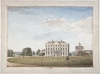 Buxted Place - 1773 | 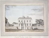 North Front of Mr Olives House in Buxted Parish - 1773 | 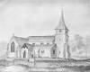 St Margarets Church - 1777 | 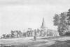 St Margarets Church - 1783 | 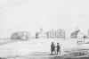 Buxted Place, West Front - 1785 | 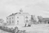 Hogge House - 1785 | 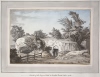 Outside of the Vineyard Rock in Buxted Parish - 1785 | |
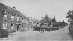
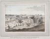 East View of the Range of Vineyard Rocks in the Parish of Buxted - 1785 | 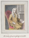 Thomas Medley of Conyboroughs, Esq., died 1728, aet 84 - 1785 | 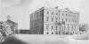 Buxted Place - 1798 | 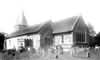 Buxted Park, Church - 1902 | 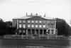 Buxted Park House - 1902 | 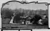 Buxted - 1903 | 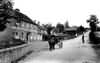 The Village - 1904 | |
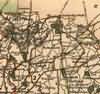
| Buxted Maps | |||||||
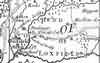 c 1724 | 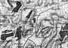 c 1795 |  c 1825 | 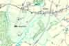 c 1875 | ||||
| Sussex Maps | |||||||
 1610 | 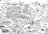 1645 | 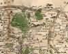 1695 | 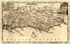 1750 | 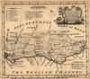 1756 | 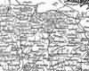 1763 | 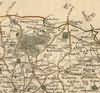 1st Sept 1787 | |
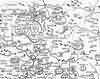
 1808 | 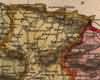 1837 | 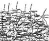 1840 | 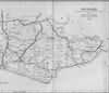 1864 | ||||
| Places and properties in Buxted - a directory of homes, farms, churches, schools, inns, and other places of interest that existed prior to 1900 has been compiled from Post Office directories, Kelly's directories, Trade directories, Census data, Ordnance survey maps and books of the period |
|
|
|
|
The Weald is at Database version 14.05 which has ongoing updates to the 395,000 people; 9,000 places; 613 maps; 3,308 pictures, engravings and photographs; and 248 books loaded in the previous version