
| Leigh |
| This Parish is about three miles and an half in length from north to south, and somewhat less than two and a half in breadth, it lies below the sand hills, in the district of' the Weald. The northern part of it lies more above ground, and consequently more dry than the parishes last described; the soil is mostly a stiff loam; the lower parts, next the river, are much subject to be overflowed. The village is in the southern part of the parish, having the church on the north side of it, and a small distance from it the seat of Hall-place, situated within the large district called Hallenden, which stretches two miles and an half north-eastward, the extremity of which, though now separated from this part of it, by the parish of Tunbridge intervening, yet by the best accounts has ever been supposed to be within this of Lyghe. The river Medway runs along the southern part of this parish, at a small distance southward from which is Endsfield. Another stream, which rises at the foot of the land-hills, bounds the eastern side of this parish, and meets the river at Tunbridge; between these is the estate and mill of Ramhurst, close to the boundary of it next to Tunbridge; about half a mile westward from the village is the ground, late the upper part of Penshurst-park, called Lyghe, alias North Park, now the property of Mr. Alnutt. Above it is Lyghe-green, between which and Hall-place there is much coppice wood, as there is in the northern part of this parish, called Westwood, near Halls and Fletchers green. A fair is held here on July 25, for pedlary ware, &c. extract from Hasted's History of Kent published in 1797 |
| Parish & other records | Before 1500 |
1500 to 1550 |
1550 to 1600 |
1600 to 1650 |
1650 to 1700 |
1700 to 1725 |
1725 to 1750 |
1750 to 1775 |
1775 to 1800 |
1800 to 1825 |
1825 to 1850 |
1850 to 1875 |
1875 to 1900 |
1900 to 1925 |
1925 to 1950 |
1950 to 1975 |
1975 to 2000 |
After 2000 |
||
| 1887 | Births | 8 | 14 | 63 | 45 | 33 | 58 | 87 | 236 | 402 | 644 | 297 | ||||||||
| 600 | Christenings | 8 | 14 | 62 | 46 | 33 | 54 | 68 | 104 | 105 | 85 | 21 | ||||||||
| 92 | Marriages | 1 | 3 | 3 | 10 | 7 | 5 | 12 | 13 | 19 | 13 | 6 | ||||||||
| 52 | Deaths | 3 | 5 | 6 | 4 | 6 | 5 | 6 | 5 | 4 | 4 | 2 | 1 | 1 | ||||||
| 60 | Burials | 3 | 5 | 7 | 5 | 5 | 5 | 10 | 5 | 5 | 2 | 3 | 2 | 3 | ||||||
| Books and other documents | |
| Published | Title, author and references |
| 1797 | The History and Topographical Survey of the County of Kent - Volume III by Edward Hasted ⇒ p. 258 |
| 1814 | An Historical, Topographical and Descriptive Account of the Weald of Kent by T. D. W. Dearn ⇒ p. 151 |
| 1839 | Directory of Kent, Surrey & Sussex ⇒ entry |
| 1840 | New Guide for Tunbridge Wells by John Colbran and edited by James Phippen ⇒ p. 257 |
| 1874 | A History of The Weald of Kent with an outline of the History of the County to the present time, Volume II by Robert Furley, F.S.A. ⇒ p. 16; p. 714 |
| 1882 | Kelly's Directory of Kent by E. R. Kelly, M.A., F.S.S. ⇒ entry |
| 1909 | English Homes and Villages (Kent & Sussex) also published as Tunbridge Wells and its Neighbourhood by Lady Hope ⇒ p. 155 |
| 1914 | Highways and Byways in Kent by Walter Jerrold with Illustrations by Hugh Thomson ⇒ p. 335 |
| Pictures | |||||||
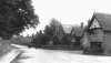 Leigh Village - 1904 |  Parish Church - 1908 | 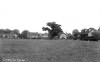 The Green - 1909 | 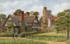 Leigh - 1910 |  Leigh - c 1920 | 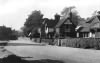 The Forge - 1965 | ||
| Places and properties in Leigh - a directory of homes, farms, churches, schools, inns, and other places of interest that existed prior to 1900 has been compiled from Post Office directories, Kelly's directories, Trade directories, Census data, Ordnance survey maps and books of the period |
The Weald is at Database version 14.05 which has ongoing updates to the 395,000 people; 9,000 places; 613 maps; 3,308 pictures, engravings and photographs; and 248 books loaded in the previous version


