
| Cowden |
| This parish, wholly within the Weald, lies at the confines of this county, adjoining to Sussex southward, from which it is parted by a stream of the Medway, which comes from one of its four principal heads, which rises at Gravely-hill in that county, whence directing its course eastward along the southern bounds of this parish, it joins the principal stream of it at Penshurst The parish of Cowden is but little known, being situated in a deep soil of clay, very wet and miry. The village, having the church on the east side, stands on a rise, though at a small distance only from the river, which here forms an elbow round the south side of it, where it turns a corn-mill; close to the river about a mile from hence is the Moat farm, and about half a mile westward that now called the Wood, both described hereafter, and at a small distance from the latter is Cowden-furnace. A small quantity of land, and two houses in this parish, were in Kilburne's time, reputed to lie within the hundred of Axstane, but more probably in that of Ruxley, as being perhaps a small part of the borough of Linkhill, parcel of that hundred. A fair is held here on the feast of St. Mary Magdalen, now on the second of August, for cattle and pedlary ware. extract from Hasted's History of Kent published in 1797 |
| Parish & other records | Before 1500 |
1500 to 1550 |
1550 to 1600 |
1600 to 1650 |
1650 to 1700 |
1700 to 1725 |
1725 to 1750 |
1750 to 1775 |
1775 to 1800 |
1800 to 1825 |
1825 to 1850 |
1850 to 1875 |
1875 to 1900 |
1900 to 1925 |
1925 to 1950 |
1950 to 1975 |
1975 to 2000 |
After 2000 |
||
| 2018 | Births | 7 | 50 | 33 | 22 | 31 | 80 | 171 | 355 | 452 | 462 | 339 | 16 | |||||||
| 969 | Christenings | 7 | 49 | 32 | 21 | 34 | 80 | 152 | 251 | 267 | 38 | 33 | 5 | |||||||
| 186 | Marriages | 8 | 14 | 5 | 6 | 8 | 21 | 29 | 38 | 24 | 7 | 15 | 5 | 6 | ||||||
| 100 | Deaths | 1 | 5 | 1 | 4 | 2 | 3 | 18 | 17 | 21 | 14 | 5 | 4 | 4 | 1 | |||||
| 117 | Burials | 1 | 5 | 1 | 4 | 2 | 3 | 17 | 18 | 31 | 15 | 4 | 7 | 4 | 5 | |||||
| Books and other documents | |
| Published | Title, author and references |
| 1766 | The History of Tunbridge Wells by Thomas Benge Burr ⇒ p. 167 |
| 1797 | The History and Topographical Survey of the County of Kent - Volume III by Edward Hasted ⇒ p. 203 |
| 1797 | The Tunbridge Wells Guide by J. Sprange ⇒ p. 147 |
| 1814 | An Historical, Topographical and Descriptive Account of the Weald of Kent by T. D. W. Dearn ⇒ p. 70 |
| 1839 | Directory of Kent, Surrey & Sussex ⇒ entry |
| 1840 | New Guide for Tunbridge Wells by John Colbran and edited by James Phippen ⇒ p. 383 |
| 1858 | Cowden and its Neighborhood by Robert Willis Blencowe ⇒ p. 111 |
| 1868 | Ancient Parochial Account Book of Cowden by The Rev. Edward Turner, M.A. ⇒ p. 91 |
| 1874 | A History of The Weald of Kent with an outline of the History of the County to the present time, Volume II by Robert Furley, F.S.A. ⇒ p. 12; p. 13; p. 27; p. 487; p. 577; p. 578; p. 579; p. 707; p. 838 |
| 1882 | Richard Tichbourne's House of Crippenden, in Cowden by Rev. W.A. Scott Robertson ⇒ p. 153 |
| 1882 | Kelly's Directory of Kent by E. R. Kelly, M.A., F.S.S. ⇒ entry |
| 1895 | Cowden Church by J. Oldrid Scott, F.S.A. & Granville Leveson-Gower, F.S.A. ⇒ p. 81 |
| 1895 | The Rectory of Cowden by Leland L. Duncan ⇒ p. 87 |
| 1895 | Notes on Three Ancient Houses in the Parish of Cowden by Granville Leveson-Gower, F.S.A. ⇒ p. 103 |
| 1926 | Cowden - The Records of a Wealden Parish by Guy Ewing ⇒ Book p. 1 |
| 2010 | Extracts from the Maidstone Journal (1786-1851) relating to Edenbridge, Hever, Chiddingstone, Westerham, Brasted and Hever by Lionel Cole ⇒ Journal |
| Pictures | |||||||
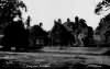
 Cowden Church - 1808 | 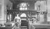 Cowden Church Interior - c 1880 | 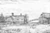 Bazing Farm - 1895 | 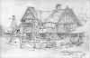 Waystrode Farm - 1895 | 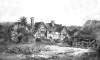 Waystrode - c 1900 | 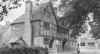 Cowden - 1905 | 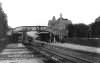 Cowden Station - 1920 | |
 Claydene - 1920 | |||||||
| Places and properties in Cowden - a directory of homes, farms, churches, schools, inns, and other places of interest that existed prior to 1900 has been compiled from Post Office directories, Kelly's directories, Trade directories, Census data, Ordnance survey maps and books of the period |
The Weald is at Database version 14.05 which has ongoing updates to the 395,000 people; 9,000 places; 613 maps; 3,308 pictures, engravings and photographs; and 248 books loaded in the previous version


