| Historical records |
|
| 731 | History | | | Ashdown Forest | Turner's Ashdown Forest |
| ... through the Saxon and Roman aeras the Forest of Anderida remained entire we have the authority of the venerable Bede. He speaks of it as such, A.D. 731, and desribes it as thick and inaccessible; and as a place of retreat for large herds of deer and swine. Wolves also, and wild boars frequented it. |
|
| 893 | History | | | Ashdown Forest | Turner's Ashdown Forest |
| ... from the Saxon chronicle we learn that in the year 893 its length from east to west was 120 miles, and its width from north to south, 30 |
|
| 1268 | History | | | Ashdown Forest | Turner's Ashdown Forest |
| From the time of the Conquest untilthe 53rd of Henry III (1268), at which time the forest was vested in the Crown, in perpetuity, it appears to have followed all the changes and chances to which Pevensey Castle was subject. |
|
| 1324 | History | | | Ashdown Forest | Turner's Ashdown Forest |
| Connected with this Forest of Ashdowne, was the Royal Palace or Hunting Seat, which stood upon it, and which Edward II is supposed to have built. Its site was on the high ground to the north of, and on the opposite side of the valley to, that on which the chapel stood. Traditionally it is placed in the wood valled the "Vechery". Here this King occasionally resided for the purposes of sport; and from his Palace at Maresfield he executed deeds in 1324 |
|
| 1372 | History | | | Ashdown Forest | Turner's Ashdown Forest |
| Edward III grants to his third son John of Gaunt the "Free-chase of Ashdon" |
|
| 1418 | History | | | Ashdown Forest | Turner's Ashdown Forest |
| As early as the fifth of Henry V. (1418), this park appears to have been subject to fraudulent usage, for in that year John Pelham ... is charged with waste by sale and destruction of timber, etc, in Ashdown Forest and Maresfield. |
|
| 1515 | | Occupation Keeper of Ashdown Forest | Sir George Neville, 3rd Lord Abergavenny | Ashdown Forest | www.thepeerage.com |
|
| 1540 | History | | | Ashdown Forest | Turner's Ashdown Forest |
| in the 31st year of Henry VIII's reign (1540), a suit was prosecuted by the King which led to the issuing of a commisssion to inquire into ... the state of the waste of the woods, the destruction of game and deer, and the decay of the park palings, on Ashdowne Forest, and to report thereon, as well as what repairs were needful to the lodges, generally, but particularily to Pypyngworth Lodge and the New Lodge. |
|
| 14th Apr 1576 | History | | | Ashdown Forest | Turner's Ashdown Forest |
| "An Extant of the Forest of Ashdowne" states that "the Parson of Marsfield ought to have by ancient custome, 16 kine, and one bull, during the whole yeare, and to have 20 hogges acquitt from pannage for the whole year" and that "the Chaplayne of Marsfield ought to have in the fforest, by ancient custome, 15 kine, and one bull on the south side of Leabrooke, during the yeare, and also with custome. And if they transgresse the bownes, pardonable. And 20 hogges by ancient custom, and acquitt of pannage. And shall have Houseboote, Hayeboote, Heathboote, and Wood for the fire, by deliverance of the Master of the fforest" |
|
| 3rd Mar 1605 | History | | | Ashdown Forest | Turner's Ashdown Forest |
| Thomas, Earl of Dorset, enforced the request of the tenants for a commossion to himself to cut down timber for repairing the pales, to enable him to preserve game in which the king delighted |
|
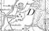
| 1610 | ![[North] Sussex](images/t/Speed1610E.jpg) | [North] Sussex by John Norden and augmented by John Speed | | Ashdown Forest | John Speed |
| The first engraved maps of the counties of Great Britain were the work of Christopher Saxton who, under the authority of the Privy Council, surveyed the English counties in Elizabethan times, from 1574 to 1578. In 1593 he was followed by John Norden who projected an ambitious scheme for a complete series of county histories. He published before his death a number of counties - Middlesex, Hertfordshire, Essex, Northampton, Cornwall, Sussex and Surrey. John Speed's map of Sussex is based upon Norden's map and was engraved by Jodocus Hondius. It occupies pages nine and ten of John Speed's Atlas entitled "The Theatre of the Empire of Great Britaine", is 20 1/4 inches by 15 1/4 inches in size and shows additionally an interesting plan of Chichester and a spirited representation of the Battle of Hastings. |
|
| 1645 | ![[North] Sussex](images/t/Blaeu1645E.jpg) | [North] Sussex by Jan Blaeu | | Ashdown Forest | Jan Blaeu |
|
| 1st Jun 1650 | History | | | Ashdown Forest | Parliamentary Surveys |
| Parliamentary Survey of Manor of Duddleswell |
|
| 18th Mar 1657 | History | | | Ashdown Forest | Parliamentary Surveys |
| Parlaimentary Survey of Ashdown Forest & Hindleap Lodge |
|
| 29th Mar 1658 | History | | | Ashdown Forest | Parliamentary Surveys |
| Parliamentary Survey of Ashdown Forest, Prestridge & Footbridge Banks |
|
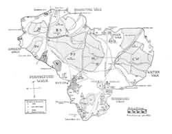
| Apr 1658 | History | | | the great Park | Turner's Ashdown Forest |
| In the Parliamentarian Survey, the great Park, with full particulars of the seven wards into which it was divided, and of the lodges standing upon them, are given with their boundaries in detail. The whole park consisted of 13,991 acres; and the seven walks are thus represented:-- South-ward and West-ward not then divided. Of this no quantities are stated, nor is the name of the keeper given.
- Pippinford walk, 704 acres, with the lodge, 21 acres; John Pranke, keeper.
- Hindeleape walk, 341 acres, with the lodge, 30 acres; Francis Hesmond, keeper
- Broadstone walk, 1108 acres, and lodge, 37 acres; John Norman, keeper.
- Coombe Deane walk, 1040 acres, and lodge, 15 acres; James Kingsland, keeper.
- Wite Deane walk, 1843 acres, and lodge, 10 acres; John Norman, keeper.
- Duddleswell walk, and lodge, 30 acres; Robert Brookes, keeper
There was also
Warren lodge and ground, 100 acres in Broadstone walk, and 744 acres in East Grinstead, Richard Gibson, tenant;
Old Lodge and ground, 9 acres;
In Coombedeane walk, in Hartfield, and waste, 1502 acres, Henry Ford tenant;
Also lands called Prestridge Bank, and Footbridge, 417 acres;
White House, otherwise Chamberlayne's House, in Maresfield, 20 acres. |
|
| 7th Jul 1658 | History | | | Ashdown Forest | Parliamentary Surveys |
| Parliamentary Survey of Duddleswell |
|
| 12th Nov 1658 | History | | | Ashdown Forest | Parliamentary Surveys |
| Parliamentary Survey of Ashdown Forest & Warren Lodge |
|
| 19th Nov 1658 | History | | | Ashdown Forest | Parliamentary Surveys |
| Parliamentary Survey of Ashdown Forest & Come Deane Lodge |
|
| 19th Nov 1658 | History | | | Ashdown Forest | Parliamentary Surveys |
| Parliamentary Survey of Ashdown Forest & Old Lodge |
|
| 19th Nov 1658 | History | | | Ashdown Forest | Parliamentary Surveys |
| Parliamentary Survey of Ashdown Forest & Broadstone Lodge |
|
| 19th Nov 1658 | History | | | Ashdown Forest | Parliamentary Surveys |
| Parliamentary Survey of Ashdown Forest & Pippinford Lodge |
|
| 19th Nov 1659 | History | | | Ashdown Forest | Parliamentary Surveys |
| Parliamentary Survey of Ashdown Forest & White Deane Lodge |
|
| 1st Apr 1662 | History | | | Ashdown Forest | Turner's Ashdown Forest |
| Subsequent to petitions and legal wranglings, the King grants the Ashdown Forest to the Earl of Bristol, for 99 years, under an annual rent of £99. However the Earls' plans for the park were frustrated "by the crossness of the neighbourhood", and when the Crown Rents fell into arrears the Crown resumed possession of the park. |
|
| 22nd Oct 1674 | History | | | Ashdown Forest | Turner's Ashdown Forest |
| Ashdown Forest is leased to Sir John Packyngton and others for a term of 31 years, who, similarily find oppsition to their plans. |
|
| 15th May 1677 | History | | | Ashdown Forest | Turner's Ashdown Forest |
| Ashdown Forest is leased to the Earl of Dorset |
|
| 22nd Nov 1677 | History | | | Ashdown Forest | Turner's Ashdown Forest |
| Ashdown Forest is leased to Sir Thomas Williams and Joseph Fell who demised the premises, with the full consent of the Crown to Alexander Staples. |
|
| 1679 to 1693 | History | | | Ashdown Forest | Straker's Ashdown Forest |
| The Ashdown Forest Dispute |
|
| 1691 | History | | | Ashdown Forest | Turner's Ashdown Forest |
| A Bill was filed in the Court of the Duchy of Lancaster in 1691, which led to a decree, by which all existing difference were adjusted, and the rights of each of the dissatisfied parties settled. |
|
| 1693 | History | | | Ashdown Forest | Turner's Ashdown Forest |
| Edmund Henslowe, master of the game in their Majesties' Forest of Ashdowne, and keeper of the king's and queen's deer filing a bill against John Erle, Thomas Davy, and others, tenants of the manor of Duddleswell, in reference to a disputed title to timber and wood, with the right of deer-hunting, and strays of cattle which the tenants claimed by the custom of the forest. |
|
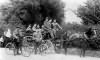
| c 1693 | 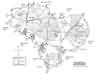 | Ashdown Forest by Barry Lucas after Kelton | | Ashdown Forest | Straker's Ashdown Forest |
|
| 1695 | ![[North] Sussex](images/t/Morden1695E.jpg) | [North] Sussex by Robert Morden | | Ashdown Forest | Robert Morden |
| Robert Morden was a London bookseller from 1669 until his death in 1703. He specialised in the geographical field and was himself something of a cartographer and a publisher. Throughout the 17th and most of the 18th centuries, there was little distinction between the activity of book or print-selling and that of publishing: many booksellers were also printers or engravers. They undertook the sale of each others' work and often combined to meet the high cost of publishing a new map or reissue of an old atlas, even if the original plates were still available. This map was published in Brittania: a chorographical description of Great Britain and Ireland by William Camden. |
|
| c 1724 | 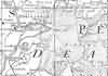 | Part of the 1 inch to 1 mile map of Sussex produced in 1724 by Richard Budgen | | Ashdown Forest | |
|
| 1756 | 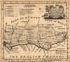 | Sussex by Emanuel Bowen | | Ashdown Forest | Emanuel Bowen |
| Emanuel Bowen was a map- and print- seller, engraver and publisher. Britannia Depicta published (1720 to 1759) was probably his first publication and he must have been gratified at its success. He continued in business until his death in 1767, and at one time help the appointments of engraver to both George II and Louis XV. Nevertheless he died in reduced circumstances. His son Thomas carried on the business until c. 1790 when he died in the Clerkswell workhouse.
In 1756 Benjamin Martin published The Natural History of England which contained the Emanuel Bowen's map of Sussex. |
|
| 1763 | ![A New Map of [North] Sussex](images/t/Kitchin1763E.jpg) | A New Map of [North] Sussex by Thomas Kitchin | | Ashdown Forest | Thomas Kitchin |
| Thomas Kitchin, an engraver and publisher from c.1738 to 1776, held the appointment of Hydrographer to the King. His output was prolific. He engraved the maps of the British and French dominions in North America by John Mitchell (1755), which was used at the peace coucil at the end of the revolutionary war. In his later years he worked with his son (hence senior after his name in the c.1755 edition of the Small English Atlas). He died in 1784. |
|
| 1st Sep 1787 | ![[North] Sussex](images/t/Cary1787E.jpg) | [North] Sussex by John Cary | | Ashdown Forest | John Cary |
| John Cary, apprenticed to William Palmer in 1770, went into business in 1783 as a publisher of maps, plans and road-books. He was highly successful and is referred to as the founder of the modern English School of Cartography by H.G. Fordham |
|
| 1808 | ![[North] Sussex](images/t/Cole1808E.jpg) | [North] Sussex by G.Cole and engraved by J.Roper | | Ashdown Forest | G. Cole |
| The British atlas; comprising a series of county maps…intended to illustrate and accompany 'The beauties of England and Wales' published 1808. |
|
| 8th Jan 1822 | Diary entry | | | Ashurst Forest | Cobbett's Rural Rides |
| At about three miles from Grinstead you come to a pretty village, called Forest-Row, and then, on the road to Uckfield, you cross Ashurst Forest, which is a heath, with here and there a few birch scrubs upon it, verily the most villanously ugly spot I ever saw in England. This lasts you for five miles, getting, if possible uglier and uglier all the way till, at last, as if barren soil, nasty spewy gravel, heath and even that stunted, were not enough, you see some rising spots, which instead of trees, present you with black, ragged, hideous rocks. |
|
| c 1825 |  | Part of the 1 inch to 1 mile map of Sussex produced in 1825 by Christopher and John Greenwood | | Ashdown Forest | |
|
| c 1875 |  | Part of the 6 inch to 1 mile map of Sussex produced in 1875 by Ordnance Survey | | Ashdown Forest | |
|
| c 1899 | 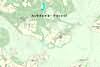 | Part of the 6 inch to 1 mile map of Sussex produced in 1899 by Ordnance Survey | | Ashdown Forest | |
|
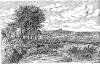
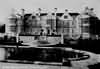
| c 1900 | 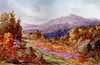 | The Ashdown Forest painted by Charles Essenhigh Corke | Charles Essenhigh Corke, artist and photographer | | English Homes and Villages |
|
| 1904 |  | Sussex Hills painted by Wilfrid Ball | Wilfrid Williams Ball | | Sussex |
|
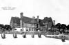
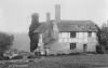
| 1925 | 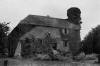 | Colin Godman, Ashdown Forest | | Ashdown Forest | Wolseley's Manor Houses |
|
| c 1925 | 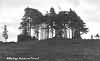 | Gills Lap, Ashdown Forest | | Ashdown Forest | Private collection |
|
| 1927 | 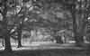 | The Glades of Ashdown Forest photographed by A.G. Wheller | | | The Sussex Highlands |
|
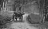
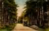
| 1927 | 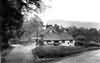 | Hatch Inn, Colemans Hatch, Ashdown Forest photographed by Francis Frith | | Ashdown Forest | |
|  The Frith archive was founded by Francis Frith, the pioneer Victorian photographer, in 1860 and today contains over 365,000 photographs of some 7,000 towns and villages throughout Britain. Taken between 1860 and 1970 these form a topographical record of Britain without equal and is recognised as probably the only photographic collection of national importance in private hands in Britain today. The Frith archive was founded by Francis Frith, the pioneer Victorian photographer, in 1860 and today contains over 365,000 photographs of some 7,000 towns and villages throughout Britain. Taken between 1860 and 1970 these form a topographical record of Britain without equal and is recognised as probably the only photographic collection of national importance in private hands in Britain today.
The importance of the Frith archive is as a topographical and social record. It provides an amazingly detailed visual record of over 7,000 towns and villages, as well as illustrating the enormous social and structural changes which have taken place in Britain since 1860. Whilst some of the photographs are undoubtedly artistically outstanding, the real value of the archive lies in its scale. There is no other archive which can illustrate this period of British history so extensively or to such a high quality. |
|
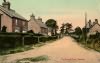
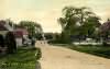
| 1928 | 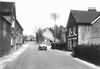 | Post Office, Nutley, Ashdown Forest photographed by Francis Frith | | | |
| The Frith archive was founded by Francis Frith, the pioneer Victorian photographer, in 1860 and today contains over 365,000 photographs of some 7,000 towns and villages throughout Britain. Taken between 1860 and 1970 these form a topographical record of Britain without equal and is recognised as probably the only photographic collection of national importance in private hands in Britain today.
The importance of the Frith archive is as a topographical and social record. It provides an amazingly detailed visual record of over 7,000 towns and villages, as well as illustrating the enormous social and structural changes which have taken place in Britain since 1860. Whilst some of the photographs are undoubtedly artistically outstanding, the real value of the archive lies in its scale. There is no other archive which can illustrate this period of British history so extensively or to such a high quality. |
|
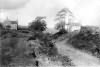
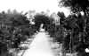
| 1928 | 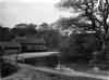 | The River, Colemans Hatch, Ashdown Forest photographed by Francis Frith | | Ashdown Forest | |
| The Frith archive was founded by Francis Frith, the pioneer Victorian photographer, in 1860 and today contains over 365,000 photographs of some 7,000 towns and villages throughout Britain. Taken between 1860 and 1970 these form a topographical record of Britain without equal and is recognised as probably the only photographic collection of national importance in private hands in Britain today.
The importance of the Frith archive is as a topographical and social record. It provides an amazingly detailed visual record of over 7,000 towns and villages, as well as illustrating the enormous social and structural changes which have taken place in Britain since 1860. Whilst some of the photographs are undoubtedly artistically outstanding, the real value of the archive lies in its scale. There is no other archive which can illustrate this period of British history so extensively or to such a high quality. |
|
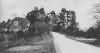
| 1936 | 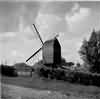 | Nutley Windmill in Summer, Ashdown Forest | | | Hemming's Windmills |
|
| 1938 |  | Little Gasson, Fairwarp, Ashdown Forest | | | Private collection |