
| Upper Brook House Easons Green Framfield |
| Historical records | |||||
| c 1875 | Part of the 6 inch to 1 mile map of Sussex produced in 1875 by Ordnance Survey | Upper Brookhouse | |||
| 1882 | Directory entry | Morley Henry, farmer, Upper Brook house | Upper Brook house | Kelly's Directory | |
| 1888 | Directory entry | Siggs, Geo, farmer, Upper Brook house | Upper Brook house | Brooker's Guide | |
| 1888 | Directory entry | Taylor, Homer, farmer, Upper Brook house | Upper Brook house | Brooker's Guide | |
| c 1899 | 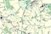 | Part of the 6 inch to 1 mile map of Sussex produced in 1899 by Ordnance Survey | Upper Brookhouse | ||
The Weald is at Database version 14.05 which has ongoing updates to the 395,000 people; 9,000 places; 613 maps; 3,308 pictures, engravings and photographs; and 248 books loaded in the previous version


