| Horsmonden |
| The Parish of Horsemonden is situated much like that of Lamberhurst, being a surface of continued hill and dale. It is bounded towards the north-east and south by different streams of the river Medway, which flow from hence, and join the main river at Yalding, besides which it is watered by two other smaller rivulets, and several lesser springs interspersed over it, all which join the larger stream on the southern side of the parish. It is full four miles in length from north to south, but its breadth is but small, in some places not more than one, and in its broadest part not more than two miles. The high road from Maidstone through Yalding to Lamberhurst and Sussex, runs through the whole length of the parish; that from Watringbury over Brandt bridge through Brenchley towards Goudhurst crosses this parish and the other road, at a small green called Horsemonden-heath, which is built round with houses, forming the only village in the parish, the rest of the houses being dispersed singly over different parts of it. The soil, near the high road, is in general a sand intermixed with the rock or sand stone, the remainder is a deep stiff clay, exceeding miry in wet weather. It is much interspersed with coppice woods of oak, especially on the west and north sides of it, where the soil abounds with iron ore; the whole is much covered with fine spreading oak trees, which here from the soil being very kindly to their nourishment grow to a large size, and become sometimes nearly equal in value to the freehold of the estates. The church stands, with the parsonage about quarter of a mile distant from it, very near the southeast boundary of the parish. In the upper part of it near the river is a seat called Baynden, late belonging to Sir Charles Booth, of Stede-hill, deceased. A fair is held here on St. Swithin's day, now by the alteration of the style on July 26, for cattle, pedlery and toys. extract from Hasted's History of Kent published in 1798 |
| Parish & other records | Before 1500 |
1500 to 1550 |
1550 to 1600 |
1600 to 1650 |
1650 to 1700 |
1700 to 1725 |
1725 to 1750 |
1750 to 1775 |
1775 to 1800 |
1800 to 1825 |
1825 to 1850 |
1850 to 1875 |
1875 to 1900 |
1900 to 1925 |
1925 to 1950 |
1950 to 1975 |
1975 to 2000 |
After 2000 |
||
| 821 | Births | 27 | 38 | 40 | 18 | 10 | 2 | 35 | 138 | 215 | 222 | 73 | 3 | |||||||
| 235 | Christenings | 27 | 37 | 27 | 14 | 9 | 15 | 42 | 41 | 23 | ||||||||||
| 47 | Marriages | 4 | 9 | 6 | 1 | 2 | 6 | 9 | 5 | 5 | ||||||||||
| 23 | Deaths | 3 | 5 | 5 | 3 | 1 | 3 | 1 | 1 | 1 | ||||||||||
| 31 | Burials | 2 | 5 | 5 | 4 | 4 | 3 | 4 | 2 | 1 | 1 | |||||||||
| Books and other documents | |
| Published | Title, author and references |
| 1797 | The Tunbridge Wells Guide by J. Sprange ⇒ p. 241 |
| 1798 | The History and Topographical Survey of the County of Kent - Volume V by Edward Hasted ⇒ p. 311 |
| 1814 | An Historical, Topographical and Descriptive Account of the Weald of Kent by T. D. W. Dearn ⇒ p. 128 |
| 1839 | Directory of Kent, Surrey & Sussex ⇒ entry |
| 1840 | New Guide for Tunbridge Wells by John Colbran and edited by James Phippen ⇒ p. 212 |
| 1874 | A History of The Weald of Kent with an outline of the History of the County to the present time, Volume II by Robert Furley, F.S.A. ⇒ p. 12; p. 107; p. 711; p. 753 |
| 1882 | Kelly's Directory of Kent by E. R. Kelly, M.A., F.S.S. ⇒ entry |
| 1885 | Cobbett's Rural Rides by William Cobbett ⇒ p. 289 |
| 1914 | Highways and Byways in Kent by Walter Jerrold with Illustrations by Hugh Thomson ⇒ p. 254 |
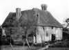
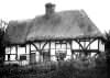
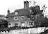
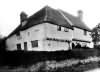
| Places and properties in Horsmonden - a directory of homes, farms, churches, schools, inns, and other places of interest that existed prior to 1900 has been compiled from Post Office directories, Kelly's directories, Trade directories, Census data, Ordnance survey maps and books of the period |
|
|
|
|
The Weald is at Database version 14.05 which has ongoing updates to the 395,000 people; 9,000 places; 613 maps; 3,308 pictures, engravings and photographs; and 248 books loaded in the previous version