
| Halstead |
| The parish of Halstead lies on high ground among the hills. It contains about nine hundred acres of land, of which about eighty are wood. The foil is either chalk or a stiff clay, much covered with flints. The Placehouse, with the church near it, is situated about half a mile westward from the high London road, leading through Farnborough towards Sevenoke, at the distance of about eighteen miles from London, on which is a hamlet called Lock's Bottom. The village of Halsted stands about a mile south-eastward from the church; southward of which the parish is bounded by a large coppice wood, reaching almost as far as Madamscott-hill, the whole of it is rather a lonely unfrequented place, having nothing further worth mentioning in it. extract from Hasted's History of Kent published in 1797 |
| Parish & other records | Before 1500 |
1500 to 1550 |
1550 to 1600 |
1600 to 1650 |
1650 to 1700 |
1700 to 1725 |
1725 to 1750 |
1750 to 1775 |
1775 to 1800 |
1800 to 1825 |
1825 to 1850 |
1850 to 1875 |
1875 to 1900 |
1900 to 1925 |
1925 to 1950 |
1950 to 1975 |
1975 to 2000 |
After 2000 |
||
| 198 | Births | 2 | 16 | 44 | 82 | 53 | 1 | |||||||||||||
| 1 | Christenings | 1 | ||||||||||||||||||
| 9 | Marriages | 2 | 7 | |||||||||||||||||
| 1 | Deaths | 1 | ||||||||||||||||||
| 0 | Burials | |||||||||||||||||||
| Books and other documents | |
| Published | Title, author and references |
| 1797 | The History and Topographical Survey of the County of Kent - Volume III by Edward Hasted ⇒ p. 13 |
| 1882 | Kelly's Directory of Kent by E. R. Kelly, M.A., F.S.S. ⇒ entry |
| Pictures | |||||||
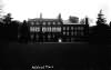 Halstead Place - 1915 | |||||||
| Places and properties in Halstead - a directory of homes, farms, churches, schools, inns, and other places of interest that existed prior to 1900 has been compiled from Post Office directories, Kelly's directories, Trade directories, Census data, Ordnance survey maps and books of the period |
The Weald is at Database version 14.05 which has ongoing updates to the 395,000 people; 9,000 places; 613 maps; 3,308 pictures, engravings and photographs; and 248 books loaded in the previous version


