
| Tunbridge Wells |
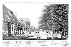 At the Pantiles with Mr Richardson in 1748 |
| The principal attraction, however, of the place is the chalybeate water. Nearly the whole of the forest ridge abounds with springs, more or less impregnated with iron, but the spring at the Wells being lower than the generality, it is less liable to be affected by changes of the atmosphere and heavy rains. The spring which is most in estimation, affords about a gallon a minute, and yields, therefore, a plentiful supply. It was for many years surrounded only by a common wooden railing. In 1664, however, Lord Muskerry, Lord of the Manor, enclosed it with a triangular stone wall, and built a hall "to shelter the dippers in wet weather." A very handsome building is now erected on the scite of the ancient enclosure, containing cold, warm, vapour, and shower baths; all excellent in their kind, and well appointed. 'The well, or basin, from which the water is supplied by the dippers, still retains its original situation, though better protected in front of the building. The water itself is extremely clear and bright, without any sort of colour; its taste is pleasantly steely; it has hardly any perceptible smell, though sometimes in a dense air its ferruginous exhalations are very distinguishable; and in point of heat, it is invariably temperate in every change of the atmosphere. It is never affected by rains, but retains an even temperature of 53° at all seasons. It is of great use in all those cases of debility for which other stimulant mineral waters are so celebrated. It is probable that at a very early period the peculiar beneficial properties of these waters were known to the persons residing in the immediate vicinity, but they were not in general repute, nor has the town been erected, till within the last two centuries and. a half. … The appearance of Tunbridge Wells, at the present period, is altogether of a different description to that of the time before alluded to. Since the erection of the new church, which was the first visible proof of the enlargement of the place, numerous buildings have arisen in various directions, but more particularly in that part of the Wells designated Mount Pleasant, or what is now more generally styled "The New Town;" built principally on the Calverley estate, belonging to John Ward, Esq. Still, however, the Parade, where the mineral springs are situated, has to boast of its assembly rooms, taverns, libraries, theatre, and a variety of shops for the sale of jewellery, toys, and Tunbridge ware. Mount Sion has also its attractions. On the top of the hill is a beautiful grove of oaks and beeches, covering a piece of land of about four acres, given in 1703, for the amusement and recreation of the inhabitants, by John Earl of Buckingham, who had, not long before, evinced his bounty in the gift of ground for the chapel of ease. extract from Horsefield's History of Sussex published in 1835 |
| Parish & other records | Before 1500 |
1500 to 1550 |
1550 to 1600 |
1600 to 1650 |
1650 to 1700 |
1700 to 1725 |
1725 to 1750 |
1750 to 1775 |
1775 to 1800 |
1800 to 1825 |
1825 to 1850 |
1850 to 1875 |
1875 to 1900 |
1900 to 1925 |
1925 to 1950 |
1950 to 1975 |
1975 to 2000 |
After 2000 |
||
| 11480 | Births | 2 | 4 | 1 | 7 | 37 | 74 | 520 | 1585 | 5437 | 3672 | 122 | 16 | 3 | ||||||
| 722 | Christenings | 7 | 29 | 56 | 206 | 226 | 152 | 39 | 7 | |||||||||||
| 96 | Marriages | 2 | 8 | 27 | 32 | 18 | 6 | 3 | ||||||||||||
| 169 | Deaths | 2 | 7 | 8 | 12 | 27 | 31 | 33 | 25 | 24 | 7 | |||||||||
| 41 | Burials | 1 | 2 | 4 | 7 | 11 | 8 | 8 | 3 | |||||||||||
| Books and other documents | |
| Published | Title, author and references |
| 1766 | The History of Tunbridge Wells by Thomas Benge Burr ⇒ Book p. x |
| 1797 | The History and Topographical Survey of the County of Kent - Volume III by Edward Hasted ⇒ p. 276 |
| 1797 | The Tunbridge Wells Guide by J. Sprange ⇒ Book |
| 1810 | Tunbridge Wells and its Neighbourhood by Paul Amsinck and Letitia Byrne ⇒ p. 1 |
| 1814 | An Historical, Topographical and Descriptive Account of the Weald of Kent by T. D. W. Dearn ⇒ p. 260 |
| 1829 | Tunbridge Wells in 1748 ⇒ p. 65 |
| 1830 | Guide of Tunbridge Wells ⇒ Book |
| 1832 | Descriptive Sketches of Tunbridge Wells and the Calverley Estate by John Britton, F.S.A. ⇒ Book |
| 1835 | The History, Antiquities and Topography of the County of Sussex by Thomas Walker Horsfield, F.S.A. ⇒ p. 421 |
| 1839 | Directory of Kent, Surrey & Sussex ⇒ entry |
| 1840 | New Guide for Tunbridge Wells by John Colbran and edited by James Phippen ⇒ Book |
| 1860 | Tunbridge Toys - Roundabout Papers No VII by William Makepeace Thackeray ⇒ p. 380 |
| 1870 | A Compendious History of Sussex - Volume II. by Mark Antony Lower, M.A. ⇒ p. 210 |
| 1874 | A History of The Weald of Kent with an outline of the History of the County to the present time, Volume II by Robert Furley, F.S.A. ⇒ p. 597 |
| 1882 | Kelly's Directory of Kent by E. R. Kelly, M.A., F.S.S. ⇒ entry |
| 1883 | Pelton's Illustrated Guide to Tunbridge Wells by J. Radford Thomson, M.A. ⇒ Book p. i |
| 1885 | Cobbett's Rural Rides by William Cobbett ⇒ p. 281 |
| 1885 | Southborough - Its Chalybeate Springs, Climate and Attractions as a Health Resort by E. Paget Thurstan, M.D., B.A., M.R.C.S., L.S.A. ⇒ p. 62 |
| 1904 | Highways and Byways in Sussex by E.V. Lucas ⇒ p. 390 |
| 1909 | English Homes and Villages (Kent & Sussex) also published as Tunbridge Wells and its Neighbourhood by Lady Hope ⇒ p. 1 |
| 1912 | Society at Tunbridge Wells in the 18th century by Lewis Melville ⇒ Book |
| 1914 | Highways and Byways in Kent by Walter Jerrold with Illustrations by Hugh Thomson ⇒ p. 309 |
| 1927 | The Sussex Highlands ⇒ p. 39 |
| 1939 | Tunbridglographia by John Playford ⇒ p. 520 |
| Pictures | more pictures | ||||||
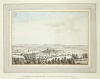
 The Springs - 1664 | 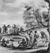 Tunbridge Wells - 1678 | 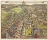 Tunbridge Wells - 1718 |  At the Pantiles with Mr Richardson - August 1748 | 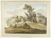 View of the Rocks near Tunbridge Wells - 1783 | 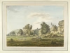 View of the Rocks near Tunbridge Wells - 1783 | 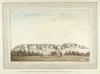 A View of the Rocks near Tunbridge Wells taken from a field on the side of the opposite Hill - 1785 | |
 The Rocks near Tunbridge Wells taken in a field near Rusthall Common - 1785 |  Mount Ephraim - 1790 |  A Perspective View of Tunbridge Wells Walks - 1797 |  Mount Pleasant - 1797 | 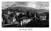 Tunbridge Wells - c 1800 | 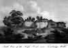 South View of the High Rocks - c 1800 |  A Perspective View of Tunbridge Wells Walks - c 1800 | |
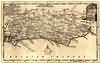
| Tunbridge Wells Maps | |||||||
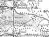 c 1724 |  c 1795 | 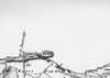 c 1825 | 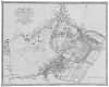 1839 | ||||
| Sussex Maps | |||||||
 1750 | 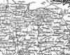 1763 | 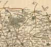 1st Sept 1787 | 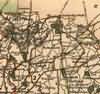 1808 | 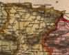 1837 | 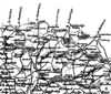 1840 | ||
| Places and properties in Tunbridge Wells - a directory of homes, farms, churches, schools, inns, and other places of interest that existed prior to 1900 has been compiled from Post Office directories, Kelly's directories, Trade directories, Census data, Ordnance survey maps and books of the period |
|
|
|
|
The Weald is at Database version 14.05 which has ongoing updates to the 395,000 people; 9,000 places; 613 maps; 3,308 pictures, engravings and photographs; and 248 books loaded in the previous version


