| Wrotham |
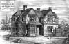
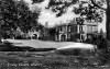
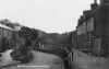
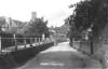
| Wrotham, commonly pronounced Ruteham. In Domesday book it is written Broteham, and in Textus Roffensis, Wroteham The village, or town of Wrotham, is situated at the foot of the great ridge of chalk hills, above the summit of which this parish extends northward. From this hill, called here Wrotham hill, which is here luxuriantly cloathed with fine spreading beech trees, there is a most beautiful prospect southward over a variety, of country, lying in the vale beneath, of vast extent, which is bounded by the sand hills at the southern extremity of it; the high road from London through Farningham Maidstone leads through this town, which is a little more than twenty-four miles from London. At the entrance of it is the mansion of the rectory, a handsome house, well suited to the income of it, and on the opposite side the road stands the church, and the small remains of the archiepiscopal palace, but yet sufficient to remind us of its having formerly been such. In the center of the town stand the marketplace and public well, both repaired by the lord of the manor; the market, which was on a Tuesday, has been disused for many years, but here is a fair held yearly on May 4, for horses, cattle, &c. Oppofite the marketplace is Wrotham place, the seat of Mr. Haddock, a further account of which will be given hereafter … extract from Hasted's History of Kent published in 1798 |
| Parish & other records | Before 1500 |
1500 to 1550 |
1550 to 1600 |
1600 to 1650 |
1650 to 1700 |
1700 to 1725 |
1725 to 1750 |
1750 to 1775 |
1775 to 1800 |
1800 to 1825 |
1825 to 1850 |
1850 to 1875 |
1875 to 1900 |
1900 to 1925 |
1925 to 1950 |
1950 to 1975 |
1975 to 2000 |
After 2000 |
||
| 354 | Births | 1 | 8 | 38 | 132 | 146 | 29 | |||||||||||||
| 3 | Christenings | 3 | ||||||||||||||||||
| 2 | Marriages | 1 | 1 | |||||||||||||||||
| 1 | Deaths | 1 | ||||||||||||||||||
| 0 | Burials | |||||||||||||||||||
| Books and other documents | |
| Published | Title, author and references |
| 1798 | The History and Topographical Survey of the County of Kent - Volume V by Edward Hasted ⇒ p. 6 |
| 1826 | A Perambulation of Kent conteining the Description, Hystorie and Customes of that Shire, written in the Year 1570 by William Lambarde ⇒ p. 456 |
| 1839 | Directory of Kent, Surrey & Sussex ⇒ entry |
| 1840 | New Guide for Tunbridge Wells by John Colbran and edited by James Phippen ⇒ p. 345 |
| 1871 | A History of The Weald of Kent with an outline of the Early History of the County, Volume I. by Robert Furley, F.S.A. ⇒ Domesday p. 225; pannage p. 254; peculiar of Canterbury p. 400 |
| 1874 | A History of The Weald of Kent with an outline of the History of the County to the present time, Volume II by Robert Furley, F.S.A. ⇒ p. 47; p. 108; p. 129; p. 163; p. 727; p. 743; p. 796; p. 797; p. 842 |
| 1882 | Kelly's Directory of Kent by E. R. Kelly, M.A., F.S.S. ⇒ entry |
| 1914 | Highways and Byways in Kent by Walter Jerrold with Illustrations by Hugh Thomson ⇒ p. 366 |
| Places and properties in Wrotham - a directory of homes, farms, churches, schools, inns, and other places of interest that existed prior to 1900 has been compiled from Post Office directories, Kelly's directories, Trade directories, Census data, Ordnance survey maps and books of the period |
|
|
|
|
The Weald is at Database version 14.05 which has ongoing updates to the 395,000 people; 9,000 places; 613 maps; 3,308 pictures, engravings and photographs; and 248 books loaded in the previous version