
| Historical notes about Uckfield |
| 1291 | History | Uckfield | Turner's Uckfield | ||
| "Buxted cum Uckfield" in Pope Nicholas' Valuation | |||||
| 1299 | History | Uckfield | Turner's Uckfield | ||
| The Lambeth Registrar mentions Uckfield Church | |||||
| 23rd Jun 1299 | History | Uckfield | Brooker's Guide | ||
| It is probable that the place [Uckfield] first rose into importance because of its being on the highway from Canterbury to Lewes and Chichester. Bishops and Archbishops made it a resting place on their journey's between these ecclesiastical centres; and an episcopal palace existing at Uckfield, making it a fit halting place for a King, we do not wonder to find Edward I resting here in 1299. "Arnald de Uckfield had the honour of entertaining his majesty ……" | |||||
| 1515 | History | Uckfield | Brooker's Guide | ||
| Farther on up the High Street he will observe, over the shop of Fisher, the harness maker, a couple of early English capitols, bearing between them the inscription OLIVE MLXV …… | |||||
| 1574 | History | Uckfield | Brooker's Guide | ||
| Iron was at one time smelted at Uckfield. The earliest mention we can find of iron works here is in 1574, when, upon a petition from Ralphe Hogge. of Buxted, " manufacturer of guns and shot for the Ordnance office," to the Council, complaining of the infringement of the patent granted him by the Queen Elizabeth for the sole exportation of ordnance, a return was procured of the owners of iron works in three counties. Among them we find "Dyvers fordgs and furnaces in Mashfield (Maresfield), Bucksted (Buxted), Franchfelde (Framfield), and Uckfelde or (Uckfield)". The Uckfield iron works were on the stream which runs from Ashdowne forest through Maresfield to Shortbridge, on the north-west borders of the parish, where the powder mills lately stood. Cast iron was frequently and appropriately used by iron masters and their families to mark their places of sepulture, during the period that iron was worked in Sussex. Iron ore is still abundant in the parish, and the only requisite to its profitable working is fuel. | |||||
| 1597 to 1598 | History | Uckfield | Buckhurst Terrier | ||
| Sir John Sackville, who was sheriff of Surrey and Sussex in the reign of Henry VIII, married Margaret Boleyn, the aunt of Queen Anne Boleyn, so that his son Richard was that queen's first cousin. This Richard Sackville was a man of outstanding ability.......He grew very rich by dealings in land in many counties, often the former possessions of suppressed chantrys and of attainted noblemen, his name appears more frequently in the Close Rolls of that period than that of any other person ............ It was jestingly said of him that his name should be Fillsack, not Sackville. He acquired the lands of the Chantry of St. Marie in 1550, those of the Fraternity of St. Katherine probably at about the same time, Tablehurst in 1559, Imberhorne in 1560, and Alchorne in 1564............... The manor of Broome, which included the greater part of the village of Hartfield, was purchased some time after 1584. Collinghurst was also in his possession at the time of his death, April 21, 1564. His only son Thomas, born in 1536, was one of the most prominent men of his time. In his earlier years a poet, he was a favourite of Elizabeth I, his second cousin.... On the 8th of June, 1567, he was knighted, and on the same day created a baron under the title of Lord Buckhurst. Alter many services to the State he was made Lord High Treasurer in May, 1599. .......Soon after succeeding to the estates at the death of his father he set about the acquisition by purchase and exchange of further manors in the vicinity of Buckhurst......The manor of Withyham, called Mounkencourts or Munkloe 1569-70; the manors of Sheffield and Tarring Peverell 1570; Ridgehill 1576; Bolebrook 1590; Lavertie 1591; Framfield in 1592; Blackham 1592; Birchden, 1595; and Bullockstown in 1585.....Sir Thomas Sackville, Lord Buckhurst, had thus in 1597 in his possession seventeen manors in north-east Sussex, including the manor of Buckhurst, as well as several others in the southern part of the rape. In view of the many recent acquisitions, and the number of leases that had been granted since 1592, it was expedient to record the seventeen in a Terrier in 1597-8 | |||||
| 1610 | ![[North] Sussex](images/t/Speed1610E.jpg) | [North] Sussex by John Norden and augmented by John Speed | Uckfild | John Speed | |
| The first engraved maps of the counties of Great Britain were the work of Christopher Saxton who, under the authority of the Privy Council, surveyed the English counties in Elizabethan times, from 1574 to 1578. In 1593 he was followed by John Norden who projected an ambitious scheme for a complete series of county histories. He published before his death a number of counties - Middlesex, Hertfordshire, Essex, Northampton, Cornwall, Sussex and Surrey. John Speed's map of Sussex is based upon Norden's map and was engraved by Jodocus Hondius. It occupies pages nine and ten of John Speed's Atlas entitled "The Theatre of the Empire of Great Britaine", is 20 1/4 inches by 15 1/4 inches in size and shows additionally an interesting plan of Chichester and a spirited representation of the Battle of Hastings. | |||||
| 1617 | History | Uckfield | Brooker's Guide | ||
| The old stone bridge of three arches …… its date, 1617, is shown by a stone removed from it when it was demolished …… | |||||
| 1631 | History | Uckfield | Brooker's Guide | ||
| The King's Commissioners of 1631, seem to have been impressed with the backwardness of this district, for they say : " We have in our division, being the wildish part of the rape of Pevensey, before and since the publishing of the Kings Majestie's orders, kept our monthly meeting att Uckfield, where wee have given the overseers in charge to make provission for the poore more plentifully, which in most places hath beene performed. …… Alehouses licensed wee have suppressed in our devision to the number of 16teene ; we have levyed the penalties upon divers unlicensed Alehouses, and transferred the forfaytures to the use of the poore ; the like we have done to many haunters of Alehouses. Vagabonds and rogues have beene by the constables soe well looked into that wee thinke the countrie hath noe cause to complayne of their nombre, and some have been punished for harbouringe of them. …… | |||||
| 1645 | ![[North] Sussex](images/t/Blaeu1645E.jpg) | [North] Sussex by Jan Blaeu | Uckfeild | Jan Blaeu | |
| 1695 | ![[North] Sussex](images/t/Morden1695E.jpg) | [North] Sussex by Robert Morden | Uckfield | Robert Morden | |
| Robert Morden was a London bookseller from 1669 until his death in 1703. He specialised in the geographical field and was himself something of a cartographer and a publisher. Throughout the 17th and most of the 18th centuries, there was little distinction between the activity of book or print-selling and that of publishing: many booksellers were also printers or engravers. They undertook the sale of each others' work and often combined to meet the high cost of publishing a new map or reissue of an old atlas, even if the original plates were still available. This map was published in Brittania: a chorographical description of Great Britain and Ireland by William Camden. | |||||
| 31st Oct 1718 | History | Uckfield | Brooker's Guide | ||
| by his will …… Dr Anthony Saunders provided for the gratuitous education of twelve boys, six of Buxted and six of Uckfield; and bequeathed his library to it, for the use of the schoolmaster and scholars for the time being. | |||||
| c 1724 | 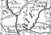 | Part of the 1 inch to 1 mile map of Sussex produced in 1724 by Richard Budgen | Uckfield | ||
| 1743 | Reflections | Uckfield | |||
Jeremiah Milles recounts a journey from London to Tunbridge Wells, Rye, Winchelsea, Hastings, Battle and Lewes. Begun August 20th, finished September 2nd, 1743 Jeremiah was born at Highclere, Hampshire in 1714, educated at Eton and Oxford. In 1741 he was elected a Fellow of the Society of Antiquaries and in the following year he became a Fellow of the Royal Society. The office of Precentor of Exeter Cathedral in 1747 was followed by that of Dean in 1762. Jeremiah Milles was at the time of his journeys through Sussex in August and September 1743 aged 29, unmarried, of independant means, with marked antiquarian interests and well travelled. At the end of his journey he leaves Lewes for Tunbridge Wells … "About eight miles from Lewes I passed through a small town called Uckfield, and a little beyond it on the right hand side Mr Medley is building a fine seat at a place called Buxted. About two mile further I came to a great heath which is part of Ashdown forest, and ascending very gently for near a mile came to the summit of the hill, where there was formerly a beacon: it is still called Crowburrow Beacon. From hence there is a most glorious prospect every way, eastward over the Weald of Sussex into Kent, southward as far as the sea, westward as far as Lewes and the downs about it, and northward of the forests of Ashdown and Waterdown and into Surrey. A gardener has built a house on the very summit of this bleak hill and has found means to raise hedges and to make a most beautiful little garden, though the whole does not enclose an acre of ground. It must be a delightful place in summer, but it is most excessively bleak and exposed to the wind. This is about 14 miles from Lewes and eight from Tunbridge Wells. Descending the hill I went in an enclosed country 'til I came within two miles of the Wells, when I came on the forest of Waterdown, which brought me late that night to Tunbridge Wells. These 22 miles from Lewes are very long and tedious, especially the first fourteen." | |||||
| 1750 | 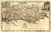 | Sussex by Thomas Kitchin | Uckfield | Thomas Kitchin | |
| Thomas Kitchin, an engraver and publisher from c.1738 to 1776, held the appointment of Hydrographer to the King. His output was prolific. He engraved the maps of the British and French dominions in North America by John Mitchell (1755), which was used at the peace coucil at the end of the revolutionary war. In his later years he worked with his son (hence senior after his name in the c.1755 edition of the Small English Atlas). He died in 1784. | |||||
| 1763 | ![A New Map of [North] Sussex](images/t/Kitchin1763E.jpg) | A New Map of [North] Sussex by Thomas Kitchin | Uckfield | Thomas Kitchin | |
| Thomas Kitchin, an engraver and publisher from c.1738 to 1776, held the appointment of Hydrographer to the King. His output was prolific. He engraved the maps of the British and French dominions in North America by John Mitchell (1755), which was used at the peace coucil at the end of the revolutionary war. In his later years he worked with his son (hence senior after his name in the c.1755 edition of the Small English Atlas). He died in 1784. | |||||
| 1st Sep 1787 | ![[North] Sussex](images/t/Cary1787E.jpg) | [North] Sussex by John Cary | Uckfield | John Cary | |
| John Cary, apprenticed to William Palmer in 1770, went into business in 1783 as a publisher of maps, plans and road-books. He was highly successful and is referred to as the founder of the modern English School of Cartography by H.G. Fordham | |||||
| c 1795 | 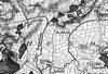 | Part of the 1 inch to 1 mile map of Sussex produced in 1795 by William Gardner and Thomas Gream | Uckfield | ||
| Jun 1800 | History | Uckfield | Brooker's Guide | ||
| On Midsummer day, 1800, …… water had accumulated in the valley in Buxted Park to a very consideable depth, owing to a portion of the park fence, which the current had torn down …… for a time to dam up the flood; but at length, overpowered, the barrier gave way, and the whole collected mass rushed forward in a great wave, with such uncontrollable impetuosity as to carry all before it. …… Two men …… were swept away by the torrent …… | |||||
| 1808 | ![[North] Sussex](images/t/Cole1808E.jpg) | [North] Sussex by G.Cole and engraved by J.Roper | Ucfield | G. Cole | |
| The British atlas; comprising a series of county maps…intended to illustrate and accompany 'The beauties of England and Wales' published 1808. | |||||
| 8th Jan 1822 | Diary entry | Uckfield | Cobbett's Rural Rides | ||
| At about three miles from Grinstead you come to a pretty village, called Forest-Row, and then, on the road to Uckfield, you cross Ashurst Forest, which is a heath, with here and there a few birch scrubs upon it, verily the most villanously ugly spot I ever saw in England. This lasts you for five miles, getting, if possible uglier and uglier all the way till, at last, as if barren soil, nasty spewy gravel, heath and even that stunted, were not enough, you see some rising spots, which instead of trees, present you with black, ragged, hideous rocks. | |||||
| c 1825 | 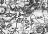 | Part of the 1 inch to 1 mile map of Sussex produced in 1825 by Christopher and John Greenwood | Uckfield | ||
| 1828 to 1829 |  | Pigot's 1828/1829 Directory for Uckfield, Fletching, Buxted, Maresfield and Nutley | Pigot's Directory | ||
| c 1830 | 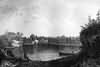 | Uckfield Lake, Uckfield by T. Henwood and engraved by Henry A. Ogg | Horsfield's Sussex | ||
| 1832 to 1834 |  | Pigot's 1832/33/34 Directory for Uckfield, Fletching, Buxted, Maresfield and Nutley | Pigot's Directory | ||
| 1837 | ![[North] Sussex](images/t/Moule1837E.jpg) | [North] Sussex by Thomas Moule | Uckfield | Thomas Moule | |
| Thomas Moule was a bookseller. He published a number of important works on heraldry and antiquities, including Bibliotheca heraldica Brittaniae in 1822. The English Counties delineated; or, a topographical description of England has a complete series of county maps and was published by Thomas Moule in 1837 | |||||
| 1839 to 1840 |  | Pigot's 1839/40 Directory for Uckfield, Fletching, Buxted, Maresfield and Nutley | Pigot's Directory | ||
| 1840 | ![[North] Sussex](images/t/Dugdale1840E.jpg) | [North] Sussex by Joshua Archer, Pentonville, London | Uckfield | Dugdale | |
| Dugdale's England and Wales Delineated | |||||
| 6th Jun 1841 | Census | Uckfield | 1841 Census Uckfield, Sussex | ||
| Uckfield Union Workhouse Enumerator - Benjamin Morris; Registrar - Charles Prince | |||||
| 6th Jun 1841 | Census | Uckfield | 1841 Census Uckfield, Sussex | ||
| Comprises the North East District, is bounded by the London Road on the West, by Browns Lane on the North and North East and by Hempsted Lane on the South. Enumerator - Thomas H. Hartley; Registrar - Charles Prince | |||||
| 6th Jun 1841 | Census | Uckfield | 1841 Census Uckfield, Sussex | ||
| Comprises the North West District, is bounded on the East by the London Road, on the North by the Budletts, on the West and South by Short Bridge Road, Isfield Road and by Church Street Enumerator - Henry Cloake; Registrar - Charles Prince | |||||
| 6th Jun 1841 | Census | Uckfield | 1841 Census Uckfield, Sussex | ||
| Comprises the South Eastern District, and is bounded on the West by the London Road, on the North by Hempsted Lane, on the South by Teeling Common and the Eastbourne Road Enumerator - Thomas Markwick; Registrar - Charles Prince | |||||
| 6th Jun 1841 | Census | Uckfield | 1841 Census Uckfield, Sussex | ||
| Comprises the South Western District, is bounded on the North by Church Street, on the East by the London Road, on the South and West by the open field. Enumerator - G.R. Rake; Registrar - Charles Prince | |||||
| 1846 | History | Uckfield | Turner's Uckfield | ||
| Uckfield made a separate piece of preferment [from Buxted], by an Order in Council | |||||
| 1851 | Directory | Uckfield | Post Office Directory | ||
| UCKFIELD is a parish and Union town 8 miles north-west of Lewes station, and 43 from London, in Loxfield Dorset Hundred, Pevensey rape, eastern division of the county and diocese of Chichester, with 1,800 acres, and a population, in 1841, of 1,534; the Income Tax assessment, in 1842, was £4,979. ........... | |||||
| 1851 | History | Uckfield | Turner's Uckfield | ||
| Population of 1,591 | |||||
| 30th Mar 1851 | Census | Uckfield | 1851 Census Uckfield, Sussex | ||
| All that part of the Parish of Uckfield which lies East of the Malling and Witchcross Turnpike Road beginning at a house called Mopbeggars and extending Southward to Uckfield Bridge and also all that part of the said Parish situate West of the High Street below and including the South side of Church Street, the Rocks and Copwood. Enumerator - John Foster. | |||||
| 30th Mar 1851 | Census | Uckfield | 1851 Census Uckfield, Sussex | ||
| All that part of the Parish of Uckfield which lies West of the Malling and Witchcross Turnpike Road beginning at the Budlets including Downland, Coombe Banks, the North side of Church Street and Shortbridge. Enumerator - Thomas Markwick | |||||
| 30th Mar 1851 | Census | Uckfield | 1851 Census Uckfield, Sussex | ||
| All that part of the Parish of Uckfield which lies South of Uckfield Bridge. Enumerator - Alfred Cloake | |||||
| 1864 | 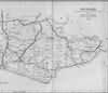 | East Sussex with the addition of the Railways by Mark Antony Lower | Uckfield | Lower's Sussex | |
| Mark Antony Lower, son of Richard Lower, born 14th July 1813 in Heathfield, school master in the early 1830s at East Hoathly, Heathfield and Alfriston; and at Lewes from 1835 to 1867; and at Seaford 1867-1871. He then moved to London where he died in 1876. He was a founder member of the Sussex Archeological Society and a prolific contributor to the collections of the society. He published
| |||||
| 1867 | Directory | Uckfield | Post Office Directory | ||
| UCKFIELD is a parish, union town, railway station, and a polling place for the Eastern division of the county, 43 miles from London, 16 from Brighton, 8 from Lewes, and 14 from Tunbridge Wells, in Loxfield Dorset hundred, Pevensey rape, Lewes county court district, and diocese of Chichester. Being close to the river Ouse, it carries on a considerable trade in timber with Lewes; there is also some trade in corn, malting, brewing, and brick and tile making. The Corn Exchange is at the Maiden's Head Hotel. ................ The parish comprlses 1,717 acres, and had a population in 1861 of 1,740. .............. | |||||
| 1871 | 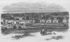 | View of Uckfield from the South | Prince's Crowborough | ||
| 1874 | Directory | Uckfield | Post Office Directory | ||
| UCKFIELD is a parish, union town, and a polling place for the Eastern division of the county, station on the London, Brighton and South Coast Company's line from Brighton to Lewes and Tunbridge Wells, 43 miles from London, 16 north-east from Brighton, 8 north-east from Lewes, and 14 south-west from Tunbridge Wells, in Loxfield Dorset hundred, Pevensey rape, Lewes county court district, rural deanery of Pevensey No. 3, archdeaconry of Lewes, and diocese of Chichester. .............. The parish comprises 1,717 acres; gross estimated rental, £8,250; rateable value, £6,645; and had a population in 1871 of 2,041. .................... | |||||
| c 1875 | 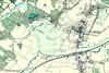 | Part of the 6 inch to 1 mile map of Sussex produced in 1875 by Ordnance Survey | Uckfield | ||
| 3rd Apr 1881 | Census | Uckfield | 1881 Census Uckfield, Sussex | ||
| The Northern part of Uckfield including part of the High Street, Maiden Head Hotel, North Row, Ringles Cross, Downland Farm, The Rocks and Church Street | |||||
| 3rd Apr 1881 | Census | Uckfield | 1881 Census Uckfield, Sussex | ||
| The Central part of Uckfield including Church Street, High Street, Whiterails and the Bell Inn | |||||
| 3rd Apr 1881 | Census | Uckfield | 1881 Census Uckfield, Sussex | ||
| The Southern part of Uckfield including the New Town, Ridgwood and Framfield Road | |||||
| 3rd Apr 1881 | Census | Uckfield | 1881 Census Uckfield, Sussex | ||
| The Uckfield Union Workhouse | |||||
| 1882 | Directory | Uckfield | Kelly's Directory | ||
| UCKFIELD is a parish, union town and a polling-place for the Eastern division of the county, station on the London, Brighton and South Coast Company's line from Brighton to Lewes and Tunbridge Wells, 43 miles from London, 16 north-east from Brighton, 8 north-east from Lewes and 14 south-west from Tunbridge Wells, in Loxfield Dorset hundred, Pevensey rape, Lewes county court district, rural deanery of Pevensey (No. 3), archdeaconry of Lewes and diocese of Chichester. The town is governed hy a Local Board of Health ; gas was introduced in 1859 and a good supply of water is obtained from many excellent springs. ............ The area is 1,717 acres ; rateable value, £8,766 ; the population in 1881 was 2,146 ................. | |||||
| 1890 | History | Uckfield | Firmin's Guide | ||
Uckfield is about 5 miles from Crowborough. The road to it is over the Beacon and the Common, and is a good and easy road for driving. It can also be reached by rail. Anciently it was a portion of the parish of Buxted, and is alluded to as a vill or outlying portion of that parish. The earliest mention of it is in Pope Nicholas's valuation in 1291. Edward I. spent a night here on his way from Canterbury to Chichester. Mr. Turner says: "The place has become singularly modern; almost everything of antiquarian value about it having, of late years, fast disappeared." From the archaeological papers we gather that "the only object of real interest is a stone room opposite the 'King's Head Inn.' The walls are of sufficient thickness to admit of arched recesses. There are double entrances, which were secured by folding doors; between these is an arched opening into a small cell. The walls have been lowered, and a house built over the room, which is now converted into a bake house, one of the arched recesses being turned into an oven. A partition wall has been erected across it, and the whole place is disfigured by shelves and tables. Te room is now below the surface of the road, which runs on two sides of it. The history of it is unknown." Mr. Horsfield connects it with the persecutions of Queen Mary. Mr. Turner thinks that though the room was used as a prison, it was not originally built for such a purpose. | |||||
| c 1899 | 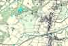 | Part of the 6 inch to 1 mile map of Sussex produced in 1899 by Ordnance Survey | Uckfield | ||
The Weald is at Database version 14.05 which has ongoing updates to the 395,000 people; 9,000 places; 613 maps; 3,308 pictures, engravings and photographs; and 248 books loaded in the previous version


